
Funded by: USGS Earthquake Hazards
Project Team:
- Frank Horowitz- Cornell
- Luis Navarrete (MSc ’15), Cindy Ebinger, Korin Carpenter, Danny Diaz-Etchevehere – University of Rochester
- Maggie Benoit, NSF and College of New Jersey
http://www.sciencedirect.com/science/article/pii/S0012821X14002246
 Project Aims
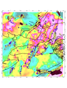
Infrequent intraplate earthquakes in the Northeastern US, which includes 14 urban areas with population > 500,000 pose risk to their population and infrastructure. Specifically, the Adirondack mountain region and its northern border with Canada, the lower St Lawrence and Lake Ontario region, and the Charlevoix region at the Maine-Canada border are some of the most seismically active regions in the Eastern US. Yet, little is known of the location and geometry of faults, suture zones, or crustal thickness variations that may localize strain in the heterogeneous crust beneath sectors of New York, Pennsylvania, and New England. Gravity and magnetic data uniquely provide the 3D perspective needed to delineate crustal domains within the Grenville, Appalachian, and Mesozoic rift and Great Meteor hotspot zones of New York, Pennsylvania, and New England, and to improve earthquake hazard assessments.
Our objectives are to systematically evaluate the geometries of crustal density and magnetic susceptibility contrasts (e.g., steep faults, intrusive bodies, Moho topography) giving rise to anomaly patterns. We will leverage the growing Earthscope seismic data sets as constraints on forward and inverse models of crust and upper mantle structure. The Earthscope seismic data sets will allow us to calibrate inverse and forward models of gravity and magnetic anomaly data in 3D, enabling a full evaluation of structural patterns. The expected outcomes of this project are maps of faults and sutures beneath New England, crustal thickness maps based on inverse models of gravity models constrained by TA and FA receiver function results, forward models of Bouguer gravity and magnetic anomalies constrained by existing geophysical and geological data to test fault interpretations in seismogenic zones, 3D spatial comparisons of faults and intrusion zones with seismogenic zones. We will prepare a final map showing seismic activity, proximity to population centers or other at-risk infrastructure, and faults, sutures, and lateral density contrasts that could be reactivated in response to stress triggering and long-term loading.