
Kinematics of Rifting in the Southern Tanganyika Rift, Africa
Funding by: Beach Petroleum
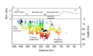 Global seismic networks document frequent and unusually deep earthquakes beneath the Western rift, East Africa. The deep seismicity means that we can use earthquakes to probe the geometry and kinematics of fault systems throughout the crust, to understand the distribution of strain between large offset border fault systems and intrabasinal faults. The southern Tanganyika rift zone has the highest seismicity rate within East Africa during the period 1973-present, yet the global seismic network, and temporary seismometer networks have been too sparse in space and time to relocate earthquakes with adequate accuracy.
The aims of a 15-month deployment of fourteen 3-component seismometers in SW 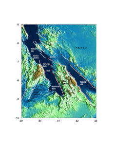 Tanzania and data from other networks in eastern Congo and Tanzania are to determine the geometry and kinematics of active faults bounding and linking the southern two basins of the Tanganyika rift, supplementing and enhancing Beach Petroleum seismic reflection data; to estimate crustal thickness variations and Vp/Vs ratios using P to S and S to P conversions of seismic energy from global earthquakes recorded on the array (receiver function analyses); estimate seismic anisotropy and its relation to extension direction, fluid pathways; evaluate seismic hazard, and update earlier hazard maps using earthquake records, and active faults mapped from geological and geophysical data sets.