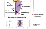
 Modern space geodetic techniques such as InSAR (synthetic aperture radar interferometry) and GPS have revolutionized the study of volcanic deformation, where one of the primary goals is to estimate the geometry of magma bodies in space and in time. These time-space volumetric relations are needed to predict changes in the state of stress within the volcanic system and to build robust eruption forecast models. However, the geodetic observations are restricted to the ground surface, and the models quickly lose resolving power with depth. This poor spatial resolution at depth can be improved significantly by using independent subsurface information. Magma intrusion events are often accompanied by increased seismicity in the vicinity of the intrusion. The migrating swarms of earthquakes have been used as an indication for the propagation of cracks that fill with magma. However, the time-space constraints provided by earthquake locations have never been used quantitatively to constrain the geometry of the magma body in an inverse problem.
Former graduate student Gabrielle Tepp and Sarah Jaye Oliva joined Dr Andrew Bell, Dr Chris Bean, Dr Mario Ruiz, and Stephen Hernandez to deploy a 14-station broadband network enclosing Sierra Negra volcano in April, 2018, two months before the major eruption phase that started June 26, 2018. SarahJaye is analyzing source mechanisms of the larger EQs, and interpreting results in light of models of GPS data in analyses by Dr Pete Lafemina and Gorki Ruiz at Penn State. Ebinger and Tepp are jointly inverting ambient noise and arrival times to produce a more detailed tomographic image of the rapidly deforming basaltic shield complex.

